
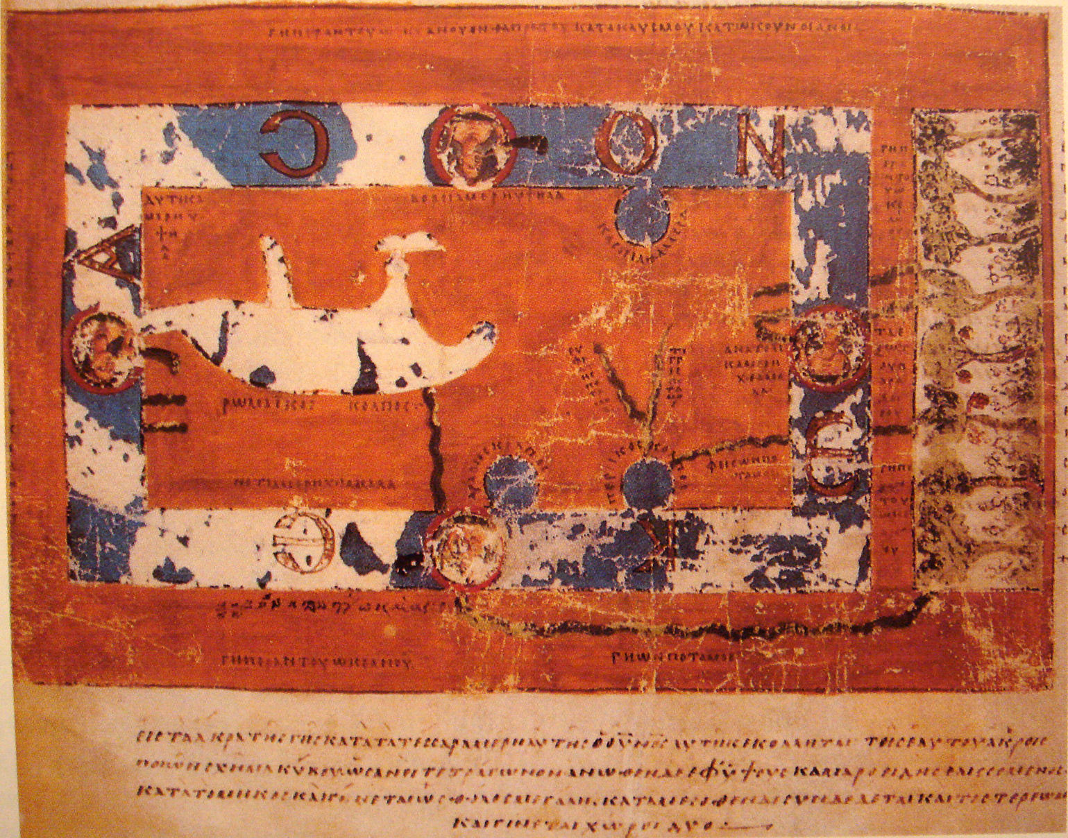
Babylonian World Map
600 BC
Earliest found world map, known as Imago Mundi. Depicts Babylon on the Euphrates, surrounded by landmasses depicting Assyria, Urartu, and other cities. Those landmasses are surrounded by Oceanus (translated as a "bitter river") and seven islands are around it in a seven pointed star. 5 of the islands have surviving accompanying descriptions.
 Anaximander's World Map
Anaximander's World Map
580 BC
Anaximander was one of Greece's first pre-Socratic philosophers, who learned from Thales and potentially taught Pythagoras. According to later Greek philosophers and thinkers, Anaximander was one of the first advocates for understanding natural phenomenon from a scientific standpoint. Strabo and Agatheremus, greek geographers, claimed that the first map of the world was by Anaximander. Previous representations of local geographies existed, but Anaximander was supposedly the first to create a global map depicting placement in the whole world.
The map was reportedly circular, with the Aegean sea at its center.Gnomonic map projection
The map was reportedly circular, with the Aegean sea at its center.Gnomonic map projection
500 BCE
Said to be oldest map projection, developed by Thales in the 6th century BCE. The map projection extends great circles as straight lines, by casting surface points of the sphere onto a tangent plane. This leads to increased distortion as the map travels away from the point of tangency with the sphere.
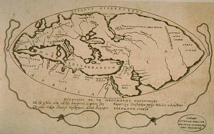
 Ges Periodos: Asia
Ges Periodos: Asia
500 BC
Written by Hecataeus of Miletus, part of two books (one for Europe, one for Asia). The Asia one describes countries and inhabitants of areas of Asia known to him, and includes a particularly detailed description of Egypt. He added a map based on Anaximander's map, but with more detail and corrections. There are 374 surviving fragments of the work.Ged Periodos: Europe
500 BC
Written by Hecataeus of Miletus, part of two books (one for Europe, one for Asia). The Europe one is a coastal survey of the Mediterranean, describing every region.Eratasthones's World Map
215 BCE
Improved world map drawn based on the conquests of Alexander the Great and his predecessors. (date is approximate, based on Eratasthones's lifespan of 276 - 194 BCE)

Note: This is an 1800s reconstruction of the map.World Globe by Crates
Note: This is an 1800s reconstruction of the map.World Globe by Crates
150 BC
World globe made by Crates in Rome, containing four continents existing on one quarter of the globe each. Three continents were unknown and theorized to be similar to Crates's own continent. Written about by Strabo in 10-20 BC, in such a way as to suggest that Strabo had a copy of a world map or globe before him as he wrote.Posidonius's world map
140 BCE
Posidonius of Apameia was a Greek philosopher who belonged to the Stoicism movement. He traveled around the Greco-Roman world of the time, and estimated the circumference of the earth with near accuracy based on his observations of the star Canopus. This was similar to the measurement of Eratasthones made by measuring levels of the sun. However, Strabo later recalculated his mapping to bring his measurement down to approx. 18,000 miles in the circumference of the earth. This measurement became a point of debate among scholars of the middle ages. Date is approximate, based on range of 150-130 BCE.
 Strabo's Geographica
Strabo's Geographica
34 BCE
Strabo's Geographica was a written account of the world based on collections of maps, previous accounts and previous (mostly Greek) geographers. His work contained maps of Europe, and the written portion informed later world maps that were credited to Strabo. Date approximate based on lifetime of 64 - 24 BCE.Pomponius Mela's World Map
43 CE
Like other ancient geographers, divided world up into 5 zones, 2 of which were habitable. However, he was unique in that he claimed the zone below the zone below the European zone was inhabited.
 Marinus of Tyre's Geographical Treatise
Marinus of Tyre's Geographical Treatise
120 CE
The treatise, lost save for Ptolemy's critique of it, was the first Roman geographical treatise to include China in its consideration and asserted that the Fortune Islands were the extent of the known world. Ptolemy acknowledged that Marinus's work was a huge source to the Geographica and references him often.Ptolemy's World Map
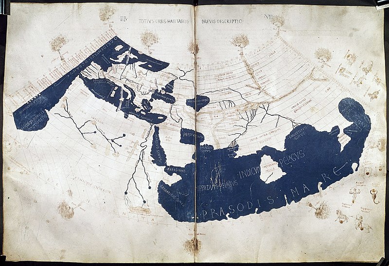
150 CE
Encompassed known world with place names and longitudinal coordinates estimated from the Fortunate Islands, the westernmost known area of the world. During Ptolemy's time, Roman military power and Roman economy made Europe aware of tracts of land in Europe, Asia, and North Africa. Ptolemy's map goes from the British Isles and Denmark in the north (including Sarmatia, modern day Poland and the Ukraine); south of the Horn of Africa (in the east); a mythological source of the Nile in the south; with a confused idea of West Africa, containing misplaced islands and no real sources.
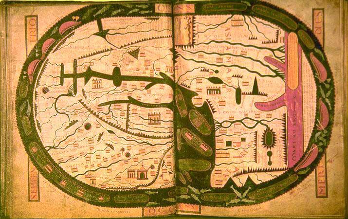
 Tabula Peutingeriana
Tabula Peutingeriana
300 CE
Roman road map that incorporated parts of Africa and Asia (mostly India). Discovered in the 16th century by German scholars.
 Christian Topography
Christian Topography
550 CE
Written by Cosmas Indicopleustes, an Alexandrian merchant who sailed the Red and Indian Seas, and provided invaluable historic descriptions of India and Sri Lanka in the 6th century. He also seemed to have personally visited India, Ethiopia, Eritrea and Sri Lanka. However, he attempted to refute previous cartographers, mathematicians, and scientists by asserting that the world is flat, not round, and that the sky takes the form of a curved lid over the world. He claimed the earth was modeled on the shape of the tabernacle, the house of worship as described to Moses by God.
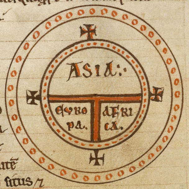
 First T and O map
First T and O map
636 CE
Described initially by Isidore of Sevilla, the T and O map took a more christian representation of the world by drawing the seas as a "t"shape, and the three known continents as the spaces divided within the O by the T. This created a depiction of a cross. The map itself was round, but this could depict either an idea that the earth was disc shaped or an understanding of the earth's roundness. Places and their distances apart could be drawn on the continents themselves. However, this is a markedly symbolic map, and not an accurate geographic representation.
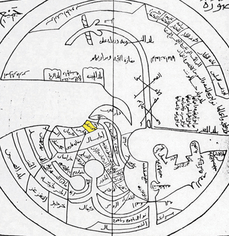
 Ibn Hawqal's World Map
Ibn Hawqal's World Map
969 CE
Ibn Hawqal was a Muslim geographer, cartographer, and writer who traveled to many areas that the Greek cartographers had previously said were uninhabitable and chronicled the inhabitants there. His world map is more representative of his travels than it is geographically accurate; however, he appears to be one of the first major cartographers to travel south of the equator and to assert the existence of native people in areas the Greeks had written off.
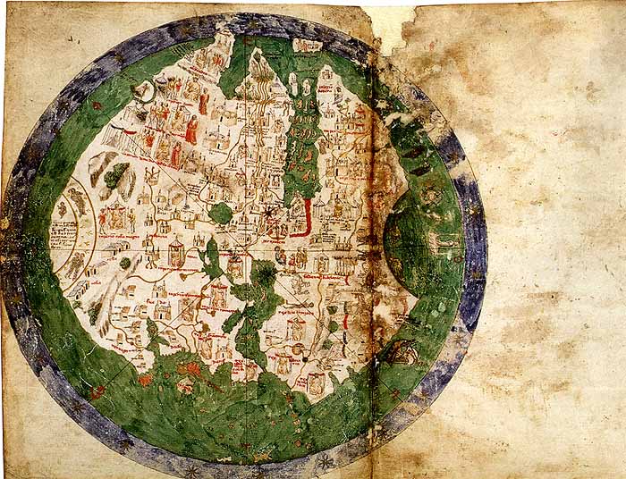
 Anglo-Saxon Cotton World Map
Anglo-Saxon Cotton World Map
1040 CE
The Latin version of the Periegesis by Priscian contains this world map. Similar to other maps of the time, particularly Christian ones, it is very symbolic with East at the top although it does not have Jerusalem near the center and there is no indication of any Garden of Eden.
 Beatus Mappa Mundi
Beatus Mappa Mundi
1050
Beatus of Liebana was an austrian monk and the author of the work Commentary on the Apocalypse. However, the world map is from a 1050 illustrated manuscript of Beatus's work, which no longer exists in its original but has been copied into other existing manuscripts.
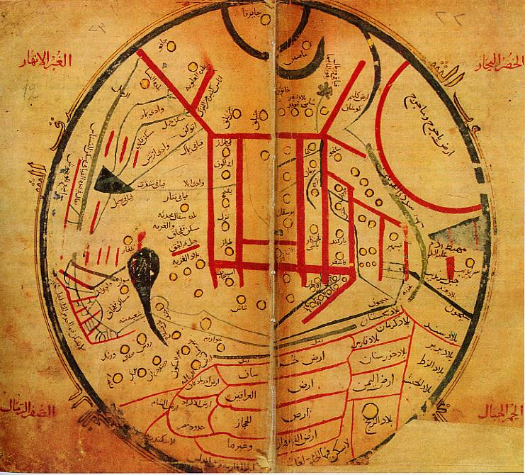
 al-Kashgari's World Map
al-Kashgari's World Map
1072 CE
Central asian scholar Mahmud al-Kashgari, from the Kara-Khanid Khanate, drew a world map centering on the Turks as a part of his compilation "Compendium of the Languages of the Turks."
 al-Idrisi Tabula Rogeriana
al-Idrisi Tabula Rogeriana
1154 CE
World map drawn by Islamic cartographer Muhamed al-Idrisi while in the court of Norman king Roger II. It was the most accurate map drawn to date and remained most accurate for some time. It was similar to Ptolemy's world map, with the exception of a greater knowledge of the east coast of China and the addition of the Indian Ocean as an open body of water and not cut off by land, like the Mediterranean. However, he still extended the east coast of Africa, which was odd given that he had knowledge of sailors sailing down past the coast and around the Saudi peninsula. This was another instance of intellectuals such as al-Idrisi preferring to trust the knowledge of their predecessors, such as Ptolemy, over colloquial knowledge of uneducated (although experienced) sailors. Ebstorf Mappa Mundi
Ebstorf Mappa Mundi
1235
One of the largest early world maps, the Ebstorf world map measures about 3 and a half meters squared. The map itself contains religious connotations and symbolism, with the format being an expanded version of the T and O map, with Jerusalem at the center and the east at the top. It was made by Gervase of Ebstorf, arguably the same person as Gervase of Tilbury, author of Otia Imperialia.
 Hereford Mappa Mundi
Hereford Mappa Mundi
1300
Similar to the Ebstorf Mappa Mundi, this map was based on the T and O style and was designed by Richard of Haldingham.
 Pietro Vesconte Mappa Mundi
Pietro Vesconte Mappa Mundi
1321
Drawn by Italian geographer Pietro Vesconte, who was one o the first to map the Black Sea and the Mediterranean Sea accurately with his nautical charts. His mappa mundi was far more accurate than any of his predecessors', particularly regarding the shape and details of coastlines.
 Catalan Atlas
Catalan Atlas
1375
Drawn by Cresques Abraham, a Jewish cartographer and leading member of the Majorcan cartographic school. It was drawn with North at the bottom of the map, and was designed in a mix of styles between the medieval mappa mundi and depictions based on travelers accounts of the time, including Marco Polo's Book of Marvels and Sir John Mandeville's Travels and Voyage.
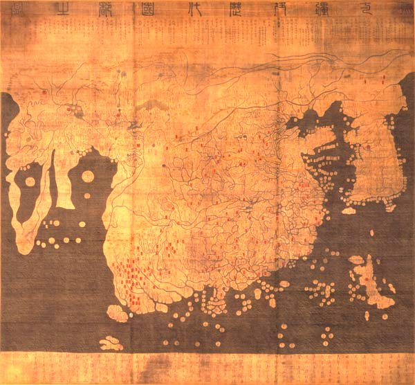
 Da Ming Hun Yi Tu world map
Da Ming Hun Yi Tu world map
1389
China never lost accurate mapping techniques that Europe did in the middle ages, and so once Europe caught up to China's techniques around 1300, the Chinese were able to use more accurate European maps of the Mediterranean to construct a world map. This world map placed China at the center and mapped the Cape of Good Hope before the Europeans would visit it. Earlier versions of the world map were made in the 1320s but the surviving copy is the elaborate one made for the first Ming emperor.
 Kangnido World Map
Kangnido World Map
1402
The "Map of Integrated Lands and Regions in Historical Countries and Capitals" was made in Korea as a part of the Joseon Dynasty's cultural projects. It uses Chinese cartographic techniques combined with western knowledge from Islamic scholars in the Mongol Empire. It is better known to the West than Da Ming Hun Yi Tu, although both are very similar with the exception of Korea's enlargement in the Kangnido map. It also has improved information of Japan, although the islands themselves are not positioned or scaled correctly. According to some scholars, the map is superior to any found in Europe before the end of the 1400s, due to its accuracy and the land it encompasses.
 Viladestes Chart
Viladestes Chart
1413
Part of the Atlas for Charles V of Spain, the Viladestes Chart depicts Africa in detail, and highlights what it refers to as a "River of Gold" crossing West Africa and joining the Nile (incorrectly).
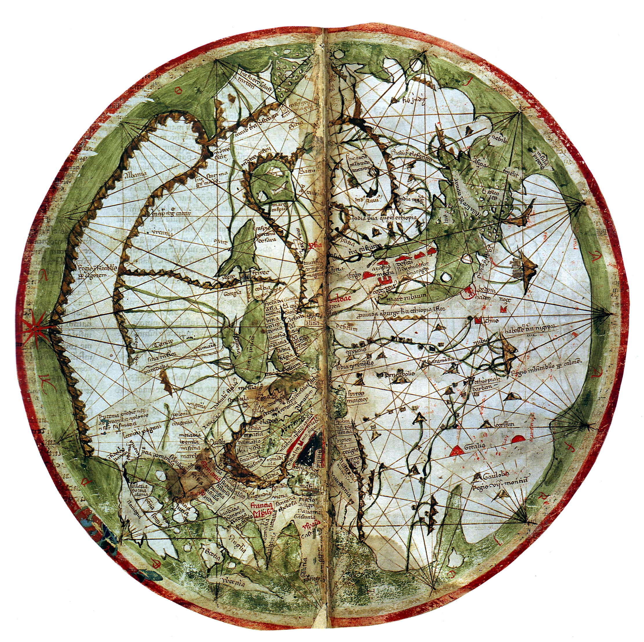
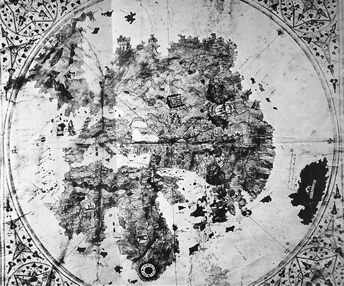
 De Virga world map
De Virga world map
1415
Abertinus de Virga, a Venetian cartographer, made this map and a 1409 Mediterranean map. This world map contains the circular geographic representation, a calendar, and two tables.
 Zheng He's Map of the World (Contested)
Zheng He's Map of the World (Contested)
1418
The map, said to be a 1763 copy of a 1418 map, has evidence both for and against it being proof of Zheng He's trip to the New World. It is surprisingly detailed, and shows the coast of California although it mistakes California to be an island and not a contiguous part of the new world. However, the fact that the map is not centered on China, and that it resembles a French 17th century world map in some of its other errors, have convinced some experts that the map is a fake. The map does match up very exactly with the accounts of his voyages that Zheng He wrote; however, a falsified map would make an effort to do the same. Essentially, the map is part of a controversy over the extent of China's exploration beyond their borders in the 15th century.
 Bianco World Map
Bianco World Map
1436
Part of Andrea Bianco's atlas of 1436. The atlas contained extensive navigation charts, other diagrams, and the circular world map. The map is potentially the first to portray Florida correctly, as there is a peninsula attached to an island labeled Antillia.
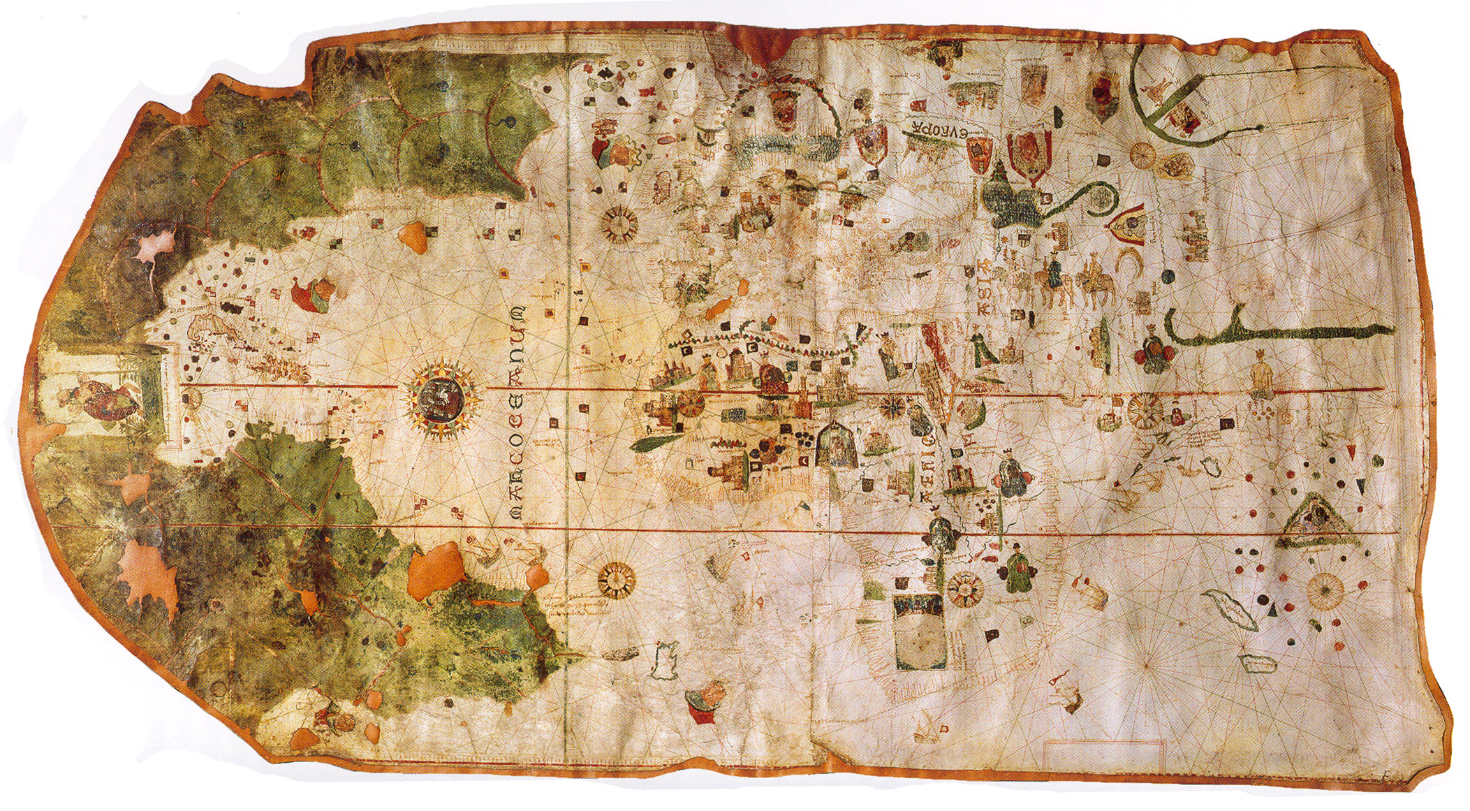
 Genoese Map
Genoese Map
1457
Based on Niccolo da Conti's accounts of his travels (rather than Marco Polo's), the map is more reasonably proportioned than other European maps. The author is unknown. Interestingly enough, the map shows a three-masted ship (a European invention) in the Indian Ocean, an event that had not yet occurred.
The ship in question:
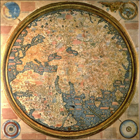
 Fra Mauro World Map
The ship in question:
Fra Mauro World Map
1459
Made in venice, the map is a circular planisphere meaning it is a projection of the earth, a sphere, onto a plane showing the sphere's appearance at a particular place/time. Made by Fra Mauro, a venetian monk, and his assistant Andrea Bianco who had previously made a world map in 1436.
 Martellus world map
Martellus world map
1490
Heavily influenced by Ptolemy (despite later, more accurate maps and accounts that existed at this time) this map was similar to the terrestrial globe by Martin Behaim in 1492. It show's Dias's voyage around the Cape.
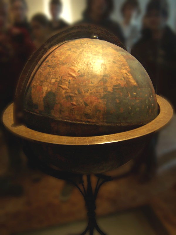
 Behaim's Erdapfel globe
Behaim's Erdapfel globe
1492
The oldest surviving globe of the Earth, it was constructed by Martin Behaim in 1492. Erdapfel (meaning 'earth apple' or 'earth potato' in German) was made of a ball of linen, laminated and reinforced with wood before being overlaid by a map painted by Georg Glockendon. It is rife with inaccuracies, leaving out the Americas entirely and enlarging the Asian islands and Japan. It may depict the Caribbean islands under the name of Saint Brendan's Island, a mythical creation.
 Chinese world map
Chinese world map
1500
Centering circularly on China, with provincial names and markers written in Chinese. China is shown as the Middle Kingdom, and other continents and countries surround its edges with only simple illustrations and a name to denote them. It is doubtful that the map was made for accuracy, but rather it depicts important elements of China, including China's central nature to the world.Juan de la Cosa mappa mundi
1500
Juan de la Cosa was a Spanish cartographer and conquistador, as well as the owner and captain of the Santa María in Columbus's first and second voyage to the Americas. His map is the first known European map including the Americas.
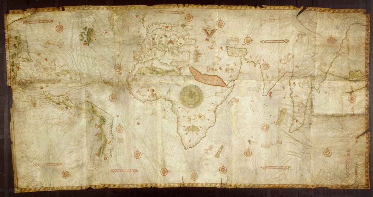
 Cantino planisphere
Cantino planisphere
1502
This is the earliest surviving map that includes Portuguese discoveries of the Americas and in the east. Although Portuguese, it is named after Alberto Cantino who smuggled it to Italy for the Duke of Ferrara. The map notably includes a partial record of the Brazilian coastline, discovered by Pedro Álvares Cabral who was not sure whether the land was connected to the land encountered farther north by Spanish explorers, or if it was an island. The map also includes Florida, the Caribbean, Africa, Asia, and Europe.
 Canerio Map
Canerio Map
1505
Hand drawn by Nicolay de Caneri, it was probably copied by Nicolay in Genoa from a similar map, the Cantino map. It includes the east coast of North America with more detail than would be expected.
 Contarini World Map: first printed map to show New World
Contarini World Map: first printed map to show New World
1506
Although not as widely published as Ruysch world map, the Contarini-Rosselini map was the first to show the New World, though not in line with Columbus's ideas about his discoveries.
 Ruysch World Map
Ruysch World Map
1507
Johannes Ruysch, from the "Low Countries" of northwest Europe (the Netherlands, Luxembourg, and Belgium) made the second oldest map of the New World. It was also publicly published and distributed. The form of the map is in Ptolemy's coniform projection, which projects the world as seen from above onto a flattened cone. The map contains information from Spanish, Portuguese, along with the misconceptions accompanying those accounts (for example, connecting Cuba and Newfoundland to Asia.) It also contains information from Marco Polo's account, but fails to represent difference between the Atlantic and the Pacific oceans, and equates Japan and Hispaniola. However, it is generally a good amalgam of all known accounts of the time of unexplored or little explored areas.
 Waldseemüller map
Waldseemüller map
1507
After years of study and collecting data from various other maps, explorers, and historical accounts, cartographers Martin Waldseemüller and Matthias Ringmann put together a collective work and world map. The map included the title "America" on the New World, suggesting that Amerigo Vespucci's discovery of the continent had more claim to its title than Columbus's encountering the West Indies. The map is rich in detail and as much accuracy as was generally available at the time.
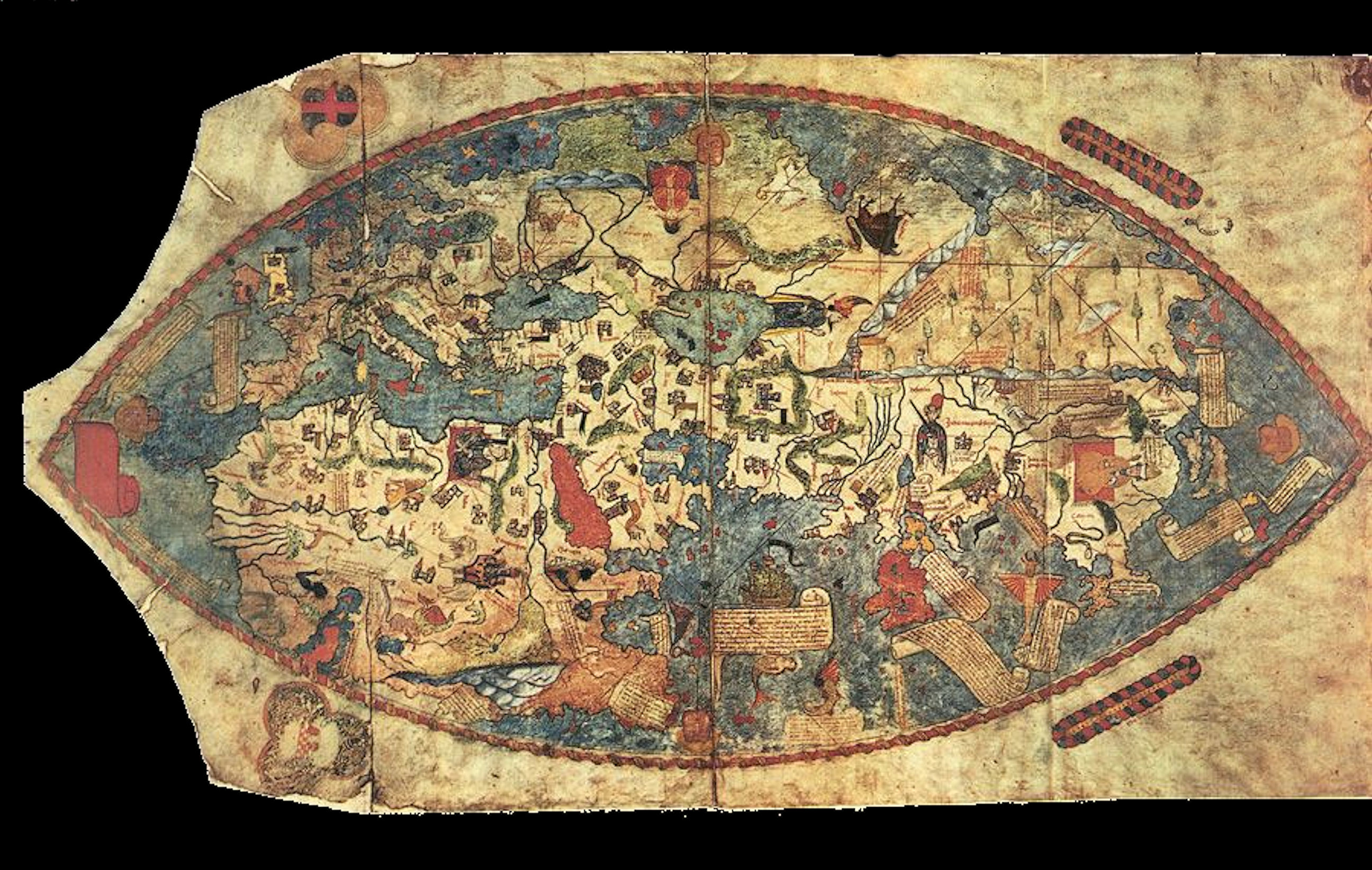
 Piri Reis map
Piri Reis map
1513
Made by Ottoman admiral and cartographer Piri Reis, only a third of the map survives but shows the costs of Europe and North America with a degree of accuracy, as well as the coast of Brazil. The map extends the American continent south-eastward from what was definitively known at the time, which some have claimed suggests at least some awareness of Antarctica, though this is controversial. Others suggest that the extension depicts South America all the way to Cape Horn, which was secretly explored by Portuguese navigators before 1507. The land mass could have been bent south-east to fit the size of parchment Piri Reis was working with.
 PIetro Coppo map
PIetro Coppo map
1520
Depicts Asia extended south, the last vestige of Ptolemy's idea of a landlocked Indian Ocean, 1500 years earlier.Diogo Ribeiro Map
1527
First world map that used latitude observations to map locations more accurately. The map's layout is influenced by the Magellan-Elcano world trip. The map fails to include Australia or Antarctica, and the Indian subcontinent is too small; however, the coasts of central and south america are precise and accurate, and it shows the Pacific Ocean properly extended. It is considered the first scientific world map.
 Pierre Desceliers world map
Pierre Desceliers world map
1550
Summarizes discoveries and cartographic innovations of past 75 years.
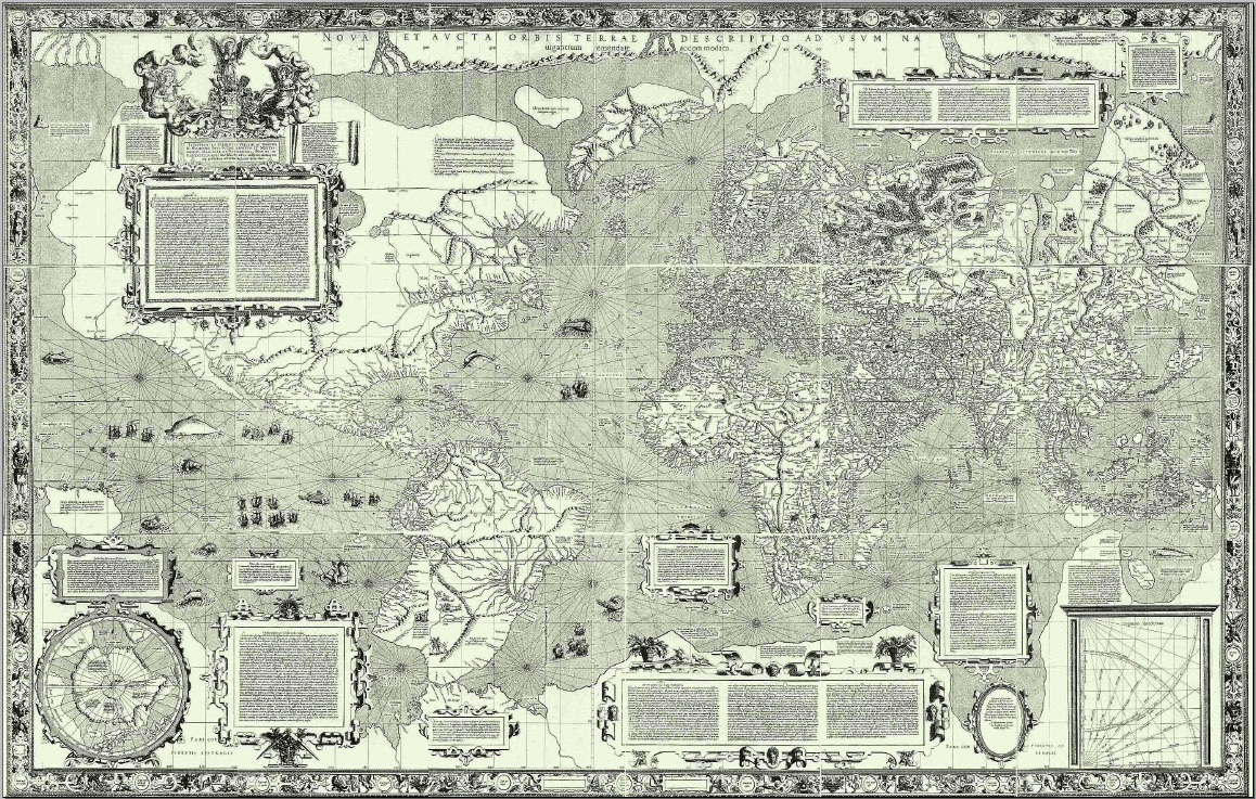
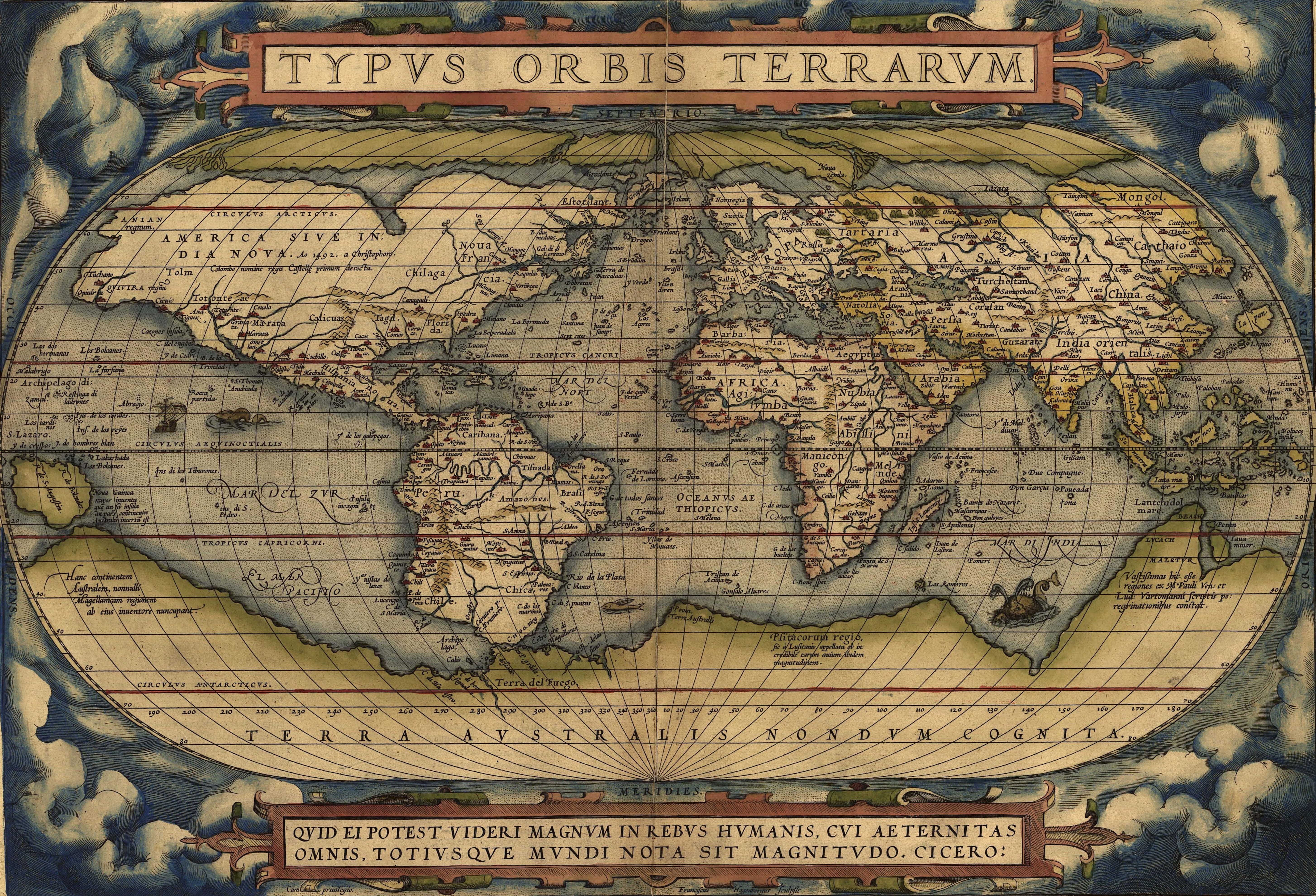
 Mercator world map
Mercator world map
1569
Gerardus Mercator introduced this cylindrical map projection which would become the world standard known as the Mercator projection. The projection distorts the size and shape of large objects while keeping smaller ones preserved, as well as preserving angles. The map was created to be used for marine navigation.
 Sinusoidal Projection
Sinusoidal Projection
1570
Appeared in a world map of 1570, done by Jean Cossin of Diepe. The Sinusoidal projection is pseudo-cylindrical and is an equal-area projection, meaning the projection shows sizes correctly but angles and orientations can be distorted.
 Theatrum Orbis Terrarum
Theatrum Orbis Terrarum
1570
Made by Abraham Ortelius and printed in Antwerp, this was the first modern atlas to be produced. It is sometimes considered a summary of 16th century cartography, containing a source list and a series of maps that were based on sources that are rare or no longer existent.
 Vaz Dourado Atlas
Vaz Dourado Atlas
1573
Depicts China, Japan, and the Korean peninsula without much accuracy, but includes illustrations of traditionally "asian" architecutre (pagodas). The geography of China is less confused than Japan and Korea; however, the placement of the major rivers is incorrect. He also writes accurately about Central America, the Middle East, and other areas of the world.


 Pieter van den Keere world map
Pieter van den Keere world map
1611
 Nova Totius Terrarum Orbis
1630
Created by Hendrik Hondius and published in Amsterdam, this map was a part of the atlas Atlantis Maioris. It was the first map to show Australia that was made publicly available.
 Transverse Mercator projection
Transverse Mercator projection
1772
Different aspect of the Mercator construction, focusing on the poles and not the equator in its accuracy.
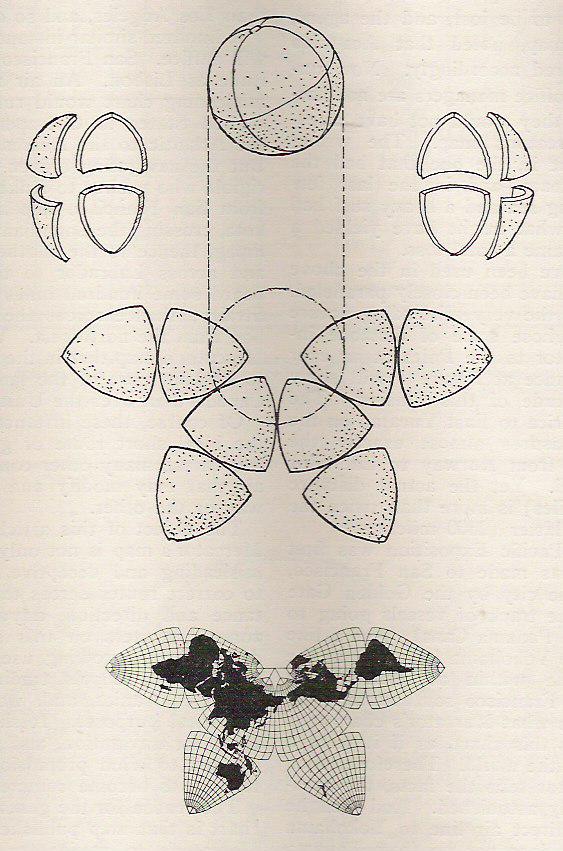
 Cahill Butterfly World Map
1909
Invented by Bernard Joseph Stanislaus Cahill, the map allows all continents to be uninterrupted while remaining true to shape, size, and form. The butterfly projection can ideally be wrapped into a ball or flattened from a ball.
 Goode homolosine projection
Goode homolosine projection
1923
Developed as an alternative to the Mercator projection, the projection has equal-area properties and similar distortions to the Mercator projection, although the representation of distances between continents is somewhat clearer. Sometimes called the orange-peel projection.
 Dymaxion map
Dymaxion map
1943
Created by Buckminster Fuller, this map projection treats the earth as an icosahedron, and preserves continental shape and size while disrupting the contiguity of the globe. Depending on the focus of the projection, the map can show the land masses as nearly contiguous or can focus on the expanse of ocean of the pacific and atlantic.

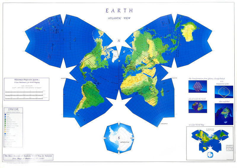
 Waterman Butterfly World Map
Waterman Butterfly World Map
1996
Like the Cahill butterfly map, this projection can be folded into a sphere and is linked in one of the oceans, typically the north Pacific or north Atlantic. Waterman's design is based on his work with packing spheres
Political/Cultural Changes
Hittites rule northeastern Anatolia
1700 BCE - 1184 BCE
The Hittites ruled an empire in the eastern Mediterranean region. They were militarily advanced, using chariots and developing weapons that were precursors to developments of the Iron Age. They wrote in cuneiform and based on archaeological records had correspondence with Egypt and the Middle East. The empire fell with the fall of the Bronze Age and split into various "Neo-Hittite" states that survived for centuries afterwards, some lasting until 800 BCE.
Shang/Yin Dynasty in China
1600 BCE - 1040 BCE
The Shang dynasty (or Yin/In, as it is referred to in Japan and Korea) ruled in the Yellow River valley of China as one of the earliest Chinese dynasties after the Three Sovereigns and Five Emperors Period of China. Archaelogical and historical evidence from this time shows the Chinese already had written language. This was during the early Bronze age.
Mycenaean Greece
1600 BCE - 1100 BCE
Period of Greek culture during the Bronze Age resulting in literature, philosophy, and writing. Homer's Iliad and Odyssey were written at this time.
Halstatt Culture in Europe
1200 BCE - 600 BCE
Halstatt culture denotes a particular archaeological culture (first found in Halstatt) that was dominant in Europe from 900-600 BCE.
Zhou Dynasty takes hold in China
1046 BCE - 256 BCE
Chinese dynasty that overthrew previous Shang dynasty and preceded Qin dynasty.
Ancient Greece: Archaic Period
800 BCE - 500 BCERoman Kingdom
753 BCE - 509 BCE
Before the founding of the Republic, period of time when Rome was ruled by a monarchy and consisted of the city of Rome and surrounding territories.
Persian Empire
539 BCE - 330 BCERepublic of Rome
509 BCE - 27 BCE
Following the overthrow of the monarchy, the Republic of Rome was based on a representative government. Most knowledge of the Roman Kingdom comes from legends and writing of this period. The hierarchical society made technological and cultural innovations, and Greek Hellenism was a particularly popular cultural influence. This was also a period of great expansion around the mediterranean as the Roman Republic came to include the entire Italian peninsula, the Iberian peninsula, North Africa, Greece, and the eastern Mediterranean.
Ancient Greece: Classical Period
500 BCE - 323 BCEWarring States Period in China
475 BCE - 221 BCEReign of Alexander the Great
336 BCE - 323 BCEAncient Greece: Hellenistic Period
323 BCE - 146 BCE
Greece expanded its political and cultural reach out to the Middle East and the greater Mediterranean. Begins with the death of Alexander the Great and ends with the Roman conquest of Greece.
Qin Dynasty, China
221 BCE - 206 BCEHan Dynasty, China
206 BCE - 220 CERoman Empire
27 BCE - 476 CE
Period after Republic, characterized by autocratic government and territorial expansion. The first two centuries of the empire were known as the Pax Romana as periods of stability and peace. At its height, the empire encompassed all of the area around and in the mediterranean, expanding up into Anatolia, through North Africa and Egypt, around the Black Sea and reaching the Caspian Sea.
Byzantine Empire
330 CE - 1204 CESui Dynasty, China
581 - 618T'ang Dynasty, China
618 - 906Korea's Goryeo Empire
918 - 1392Song Dynasty, China
960 - 1279Mongol Empire
1206 - 1368
Under Genghis Khan, the Mongol Empire emerged from unifying Mongol and Turkic tribes in Mongolia. It invaded and grew in all directions. The empire connected east and west and ultimately allowed the dissemination of goods, ideas, and technologies throughout Eurasia.
Yuan Dynasty, China
1279 - 1368Ottoman Empire
1299 - 1923Ming Dynasty, China
1368 - 1644Korea's Joseon Dynasty
1392 - 1897First European Colonization Wave
1415 - 1830
1482
Spanish colonization of the Americas begins
1493
First English colony established: Roanoke
1585
Established by Queen Elizabeth I, the colony lacked supplies and did not have friendly relations with the Indians whose island they were living on. However, their disappearance did not seem forced or hurried, although they had asked for extra supplies and passage out of the New World three years prior to the disappearance.
Qing Dynasty, China
1644 - 1912Scientific/Tech Influences
Iron Age: Ancient Near East
1300 BCE - 600 BCE
Egypt, Cyprus, Aegean, Anatolia,, Assyria, Caucasus, Levant, Persia
Iron Age: Europe
1200 BCE - 400 ADIron Age: India
1200 BCE - 200 BCEIron Age: China
600 BCE - 200 ADIron Age: Nigeria
400 BCE - 200 CEIron Age: Korea
400 BCE - 50 CE
206 BC
Iron Age: Japan
100 BCE - 500 CEFirst recorded use of a compass in Western Europe
1187 - 1202
1300
Gutenberg's Printing Press (movable type)
1450
Teloscopes used in Netherlands
1608
Vernier scale invented
1631
Added to sextants and other navigational devices, the vernier scale is a sliding secondary scale that shows where a measurement is between two marks of the main scale.
 Octant (precursor to the Sextant) developed
Octant (precursor to the Sextant) developed
1730
John Hadley and Thomas Godfrey both developed the octant independently but att he same time, Hadley in England and Godfrey in Philadelphia.First Sextant produced
1757
Made by John Bird in England, the sextant was used to determine angle between 2 objects, often used to find the altitude of a star tot he horizon. It represented a major advance in navigation.Lithography invented
1796
Lithography was a printing method that vastly cheapened the process of making reproductions of images, and made maps and their distribution more readily available.GPS becomes operational
1994
Global Positioning System is a satellite navigation system that gives location, time, weather, and other information about any location on Earth, and is used by modern cartographers to accurately place geographic locations and shapes.
Europe
Greek colonization of the Mediterranean and the Black Sea
800 BC - 400 BC
300 BC
Told by Strabo, a Greek philosopher and geographer, and provided the Greeks and Romans with information about Northern European geography before Julius Caesar. May have reached Iceland in his journey, touching the Norwegian coast and sailing around Britain and through the Baltic and North Sea.
Voyage of St. Brendan the Navigator
512 - 530
An Irish saint and traveler, there are accounts of St. Brendan sailing to the "Isle of the Blessed", which some believe to be an island of the Americas, potentially one in modern day Canada.
Norsemen settle and colonize Greenland
980 - 1430
Norsemen traveled to explore and colonize Greenland, ultimately creating an Eastern and a Western settlement (with potentially a Middle settlement, smaller than the other two, existing near the Western one). The settlements were farming based, and accepted the Norwegian king in 1261 as their overlord. The colony declinde in the 14th century, with the western settlement abandoned in 1350 and the last recorded activity in the settlements dating to 1430.
Norse exploration of North America
985 - 1010
Although no long-term colonies or settlements were placed here, several Norse expeditions came to North America, staying a few years in Vinland ("land of wine" or "land of meadows") and visiting areas surrounding it.
Majorcan cartographic school
1250 - 1480
In Majorca, a group of Jewish cartographers and navigational tool makers worked in the 13th through 15th centuries. They had some Christian associates, but the predominantly successful mapmakers were jewish. They remained in Majorca until the Spanish Inquisition and the subsequent expulsion and persecution of Jews.
Latin translation of Strabo's Geographica appears in Western Europe
1469 CE
European colonialism/expansionism takes hold
1480 CE - 1530 CE
Period of European financial expansion and political takeovers of Africa, Asia, and America. Several technological advances at and before this period allowed European explorers and empires to swiftly take claim over regions of the world that were previously unknown to Europe or thriving under their native rulers and civilizations. After this period, the study of cartography become more of a history of European graphical knowledge. After these discoveries, the finality of European influence and expansionism become certain.
Bartolomeu Dias rounds the Cape of Good Hope
1488
Beginning of the Age of Discovery
1492
Columbus's first voyage to the Americas marked the beginning of the age of discovery, by inciting the rest of Europe to further exploration and by conclusively connecting the Americas and Europe in a way no previous exploration had. Having reached Cuba, columbus claimed he had reached Asia and received awards and acclaim back in the Spanish court for his discoveries, which included tobacco, pineapple, turkey, and the hammock. He also brought back natives form Cuba, who he presented to the Spanish court.
Christopher Columbus discovers islands in the New World
1492
Although he believed he had reached Asia, Columbus encountered the Canary Islands and the Bahamas. He was not the first to encounter the New World, but he was the first to maintain permanent and irreversible contact between Europe and the New World.
Vasco da Gama travels to India
1498
Magellan's Voyage to Circumnavigate the World
1519 - 1522
Ferdinand Magellan set out with 5 ships on a voyage to prove that Spain had ownership of the Spice Islands by proving there was a direct sea passage to them. However, he died during the trip after attempting to convert a native chief to christianity, and his crew continued on without him. Other difficulties meant that the end of the voyage saw 18 men in one ship returning to Spain, having successfully circumnavigated the world, but at a cost.
Australia discovered by Willem Janszoon
1606
Dutch explorer and navigator Willem Janszoon discovered Australia in 1606, and attempted to name it Neu Zeeland (a name that was later taken for modern-day New Zealand). He returned to Australia in 1616.
Tasmania and New Zealand discovered by Abel Tasman
1642
Asia
Phoenicians sail around coast of Africa
600 BC
Told by Herodotus, provided rudimentary information in the form of storytelling about the coastal geography of Africa.
King Darius of Persia sends Greek envoy to explore Indus
510 BC
Greek envoy Scylax of Carynda becomes first known European to see India, as he traveled to the Kabul River and by sea to the Indus before sailing west to the Arabian peninsula and up the Red Sea.
Fa Hsien's journey
399 CE - 414 CE
Although journeys from China to other countries were rare, occasionally journeys to India were undertaken by Buddhists, as pilgrimages and fact-finding missions. Fa Hsien's journey passed across the Takla Makan desert, through Kashmir and the Ganges and over sea to Ceylon and Java.
al-Idrisi's stay at the Norman Court
1140 CE - 1155 CEMarco Polo's travels in Asia
1271 - 1295
Lasting for 24 years, Marco Polo set off with his uncle and father when he was 17 to Asia, documenting his adventures that were later published in Marco Polo's book.
Zheng He's naval voyages (Contested)
1405 - 1435
Zheng He, a Chinese admiral was said to have made voyages across the Pacific, and reaching the western coast of North America in modern-day California. However, some say that he did not, in fact, reach the New World and the map that is purported to be a copy of his original is a fake.
Fonte: https://www.preceden.com/timelines/70571-cartography--an-overview
Nenhum comentário:
Postar um comentário